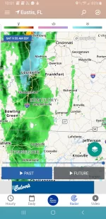
.Short Term...(Today and tonight)
Issued at 340 AM EDT
Sat Apr 20 2019
Moderate to at times heavy rain continues over portions of southwest
Ohio through southern Indiana into west central Kentucky in the
deformation band of a
low pressure system passing just to our east.
The latest high-res models suggest these steady moderate to at times
heavy rains should continue through about 5-7am before tapering to
light rain.
Radar rainfall estimates early this morning indicate 1-
2.5+ of rain has fallen along an axis from roughly
Ohio/Hancock/Perry to Floyd/Clark counties. No flooding reports in
the worst of these areas so far, but night time flooding can be
difficult to pin down. Have issued
Flood Advys and
Flood Warnings
along this axis largely based on
radar rainfall estimates and precip
observations nearby in conjunction with 3-6
hr FFG. Use caution if
you happen to be out driving in the heavier rains early this morning
especially before sunrise when
flood waters are more difficult to
spot.
In addition to the
rainfall, the
NAM and HREF still indicate the
possibility of a brief mix of rain/snow along the I-65 corridor
around sunrise. Still not convinced this will happen based on other
guidance but will continue to monitor AMDAR soundings and dual
pol parameters for potential p-type change overs.
By mid morning expect light rain across the area with precipitation
slowly becoming less in coverage throughout the day as
moisture
thins. There may even be a period of light drizzle this
afternoon/evening before precipitation exits all together from west
to east. Expect high temperatures to range through the 40s today
over much of the area. Portions of west central KY that see late
afternoon clouds clearing may reach the low 50s for highs.
